The new Australian Warning System is being rolled out and will provide, for the first time, a national approach to issuing warnings for hazards such as cyclone, flood, storm, extreme heat, bushfire and severe weather.
The three-tiered system that is currently in place for bushfire is unchanged and will, in time, be applied to other hazards:
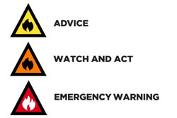
- Advice (yellow): An incident has started. There is no immediate danger. Stay up to date in case the situation changes.
- Watch and Act (orange): There is a heightened level of threat. Conditions are changing and you need to start taking action now to protect yourself and your family.
- Emergency Warning (red): An Emergency Warning is the highest level of warning. You may be in danger and need to take action immediately. Any delay now puts your life at risk.
In addition to the expanded use of these calls to action, all states and territories will employ a consistent set of icons [bushfire icons, below] to show active incidents on websites and apps:
Watch this short video to understand the icons and warnings, and this information sheet provides background – and a graphical guide – to how councils and other authorities will employ the new national standard.
Australasian Fire and Emergency Services Authorities Council (AFAC) research of some 16,000 people found extensive support for the three-tiered system and Queensland councils were among those consulted through the system’s expansion to encompass other hazards.
The Commonwealth Minister for Emergency Management, David Littleproud, says “[it] is one tool in the suite of emergency warning mechanisms that state and territory emergency service organisations have at their disposal, and I commend [AFAC] for its development.” Minister Litteproud's full statement is available here.
For more information, view the Australian Institute for Disaster Resilience's website.